Distance: 14.6 mi. out and back Elevation gain: 2225 ft
Kaiser Pass is not my favorite ride in the area. In fact, I’d say it’s only pretty good. But when I was preparing to ride in the area, everyone I talked to said it was the premiere ride east of Fresno. So, because it’s likely that you’ll hear the same, I’m going to describe it so you know what you’re getting into.
Kaiser Pass Road is a 7.3-mile climb from the east end of Huntington Lake to the summit. Its consummate virtue, in this area, is that it isn’t burned. The maps of the Creek Fire show it burning all around Huntington Lake, and in fact the south shore is largely burned once you get away from the shoreline, but KPR itself is entirely, sweetly lined with healthy conifers. Still, the bulk of the ride I find slightly monotonous Green Wall riding. On the return, the descent is long, straight, and fast, so if you like such things this might be the ride for you.
Start at the intersection of Hwy 168 and Kaiser Pass Rd. The climbing begins immediately—if you want to warm up, the 6 miles of Huntington Lake Rd. along the north shore are easy rollers and totally pleasant riding.
The lower miles—note the road surface
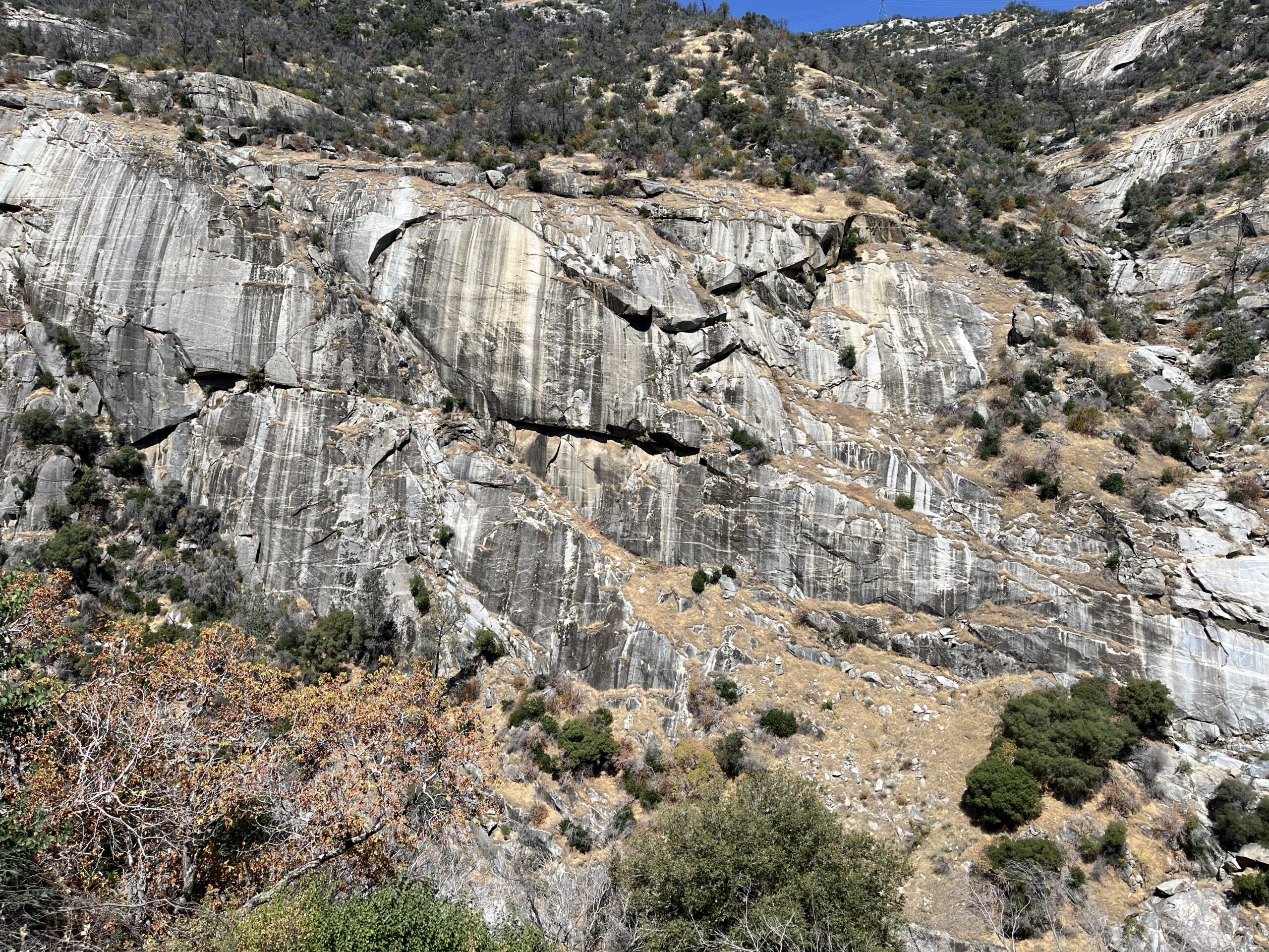
Tthe first 5 miles of KPS I find tedious—Unvaried moderate climbing on a big, wide, relatively straight road without distinguishing feature or variety. About 2 miles from the summit, the road completely changes character—from big to small, from straight to meandering, from an unvaried pitch to up and down, from smooth road surface to sketchy. The landscape improves, because you get above the green wall and start seeing some nice granite. Now you’re IN the Sierra instead of riding past it. I like those last 2 miles a lot. Near the end of the ride there are some nice vistas looking westward over the terrain you’ve just traversed, all unburned forest.
The upper miles
The pass itself is easy to miss. There is a false summit and some signs for turn-offs to Badger Flat just before it, but there is no signage at the summit itself—only two outhouses, a dirt parking area, and a slight downhill to the east. Of course Kaiser Pass Rd. continues on, but the road surface becomes even sketchier (see Adding Miles below).
Once back to the wide, smooth road, the return ride is that sort of thing you may love and I don’t: a 35-45 mph rocket-sled descent without much to do except sit there, in a straight line or on the occasional curve so gentle it might as well be straight. The road surface consists mostly of those little vertical grooves cut into the pavement to aid car traction in the snow, and it’s just disruptive enough to be a slight flea in the ear.
From near the top looking westward
Shortening the ride: Depending on your taste, you might prefer the first 5 miles or the second 2.
Adding miles: As I mentioned, the miles along the north shore of Huntington Lake (Huntington Lake Rd.) are a pleasant, pretty way to add 12 miles (out and back), with some classic, unpretentious Sierra mountain lake resorts along the route. Fire damage is nil until the very west end.
You can continue riding east past the Pass. The road runs for c. 17 more miles, mostly moderate descending, and becomes rougher and smaller, until it’s little more than a track. It takes you to Mono Hot Springs, a locale of considerable interest, and then on to Edison Lake, where it dead-ends just past the Vermilion Valley Resort, which offers you the possibility of overnighting before the ride out. I hear good things about it. Streetview will let you preview almost the entire route.
You can continue riding west from our starting point, but both alternatives have their drawbacks, Hwy 168 has some nice contour but can be very trafficky (especially on weekends), and Big Creek Rd. (discussed at length in the Million Dollar Road ride) is a dauntingly steep descent.
Distance: 25.3 mi. out and back Elevation gain: 2988 ft
This is one of the many good foothill rides in the area between Fresno/Clovis and Shaver Lake. This short out-and-back has two features that make it stand out from the others:
1. A killer descent. It’s 9 miles of 30-45-mph rocket sled ride on near-perfect road surface through short straights and wide, lazy turns. Pretty much bliss.
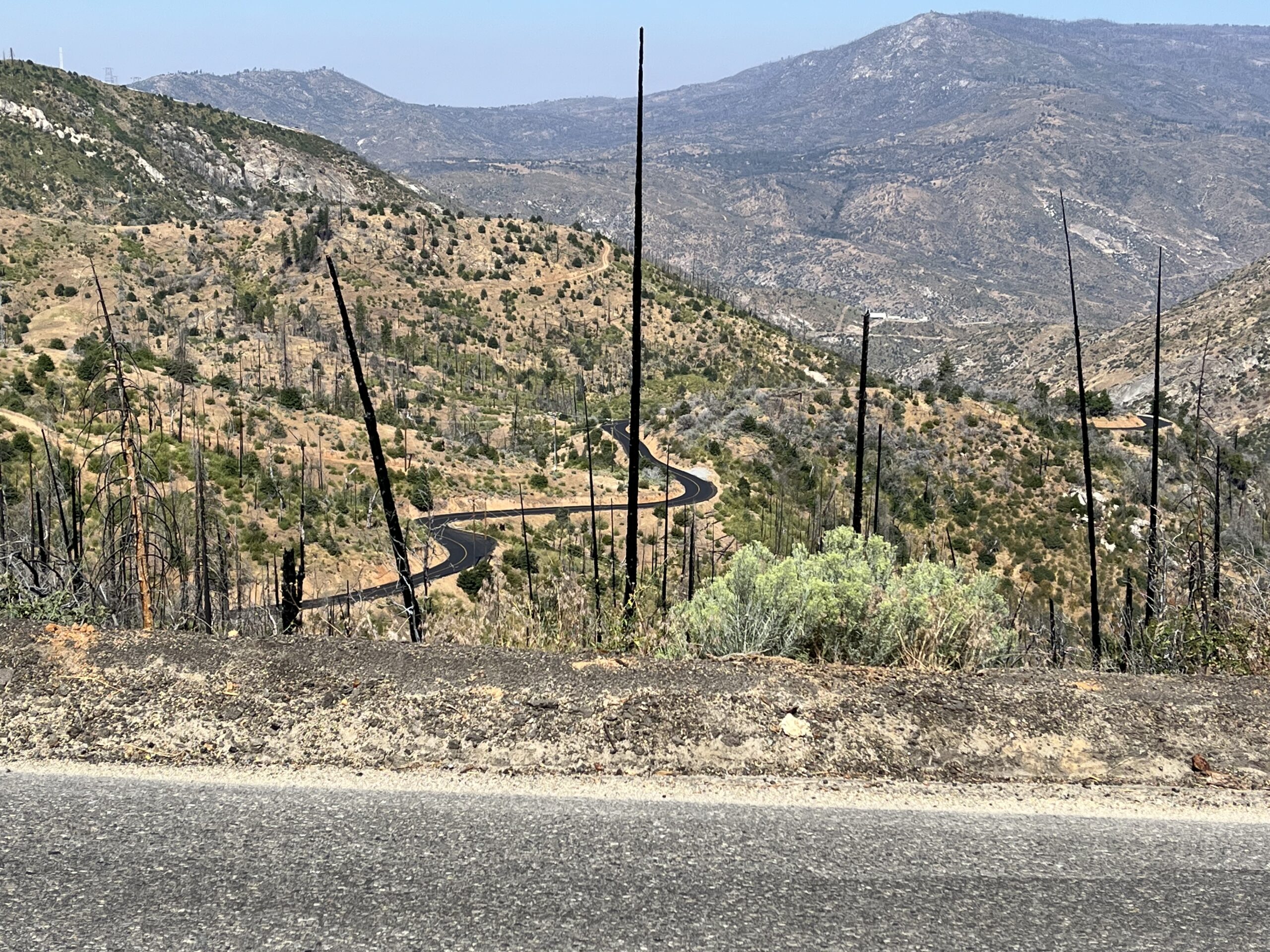
2. The vista. For much of the climb, you can see forever to the west and north. A lot of it was hit by the great Creek Fire burn of 2020, and it’s pretty scrubby landscape anyway, but it’s big.
Of course that descent means the ride out is 9 miles of uninterrupted moderate climbing through the local roadside scenery, which, thanks to the Creek Fire, is nothing special—scrub, with the occasional low-rent ranch—and were it not for that descent and the view, it would be a fairly generic ride.
The Clovis valley sees 100-degree temps in the summer. This ride is just out of the valley, so expect summer temps well into the 90’s. Thanks to the fire, there is little shade. Ride in the spring or the morning.
Begin in the town of Auberry, which miraculously contains two automotive garages and a fine mom-and-pop grocery store, and almost nothing else. Ride to the end of Auberry Rd., then ride back.
Kinda generic going up, swell coming down
If you’re looking for food after the ride, I recommend Velasco’s in nearby Prather.
Shortening the ride: Turn around anywhere on the climb. The further you ride, the longer the descent.
Adding miles: You can loop this ride by riding from the town of Auberry on Lodge Rd. to Toll House Rd. to the east end of Auberry Rd. back to Auberry. There’s an even bigger loop consisting of Auberry Rd. heading westward from Auberry to Millerton Rd. to Toll House Rd. to the east end of Auberry Rd. and back to Auberry. Just remember to ride any loop counter-clockwise, so you get the Auberry Rd. downhill.
From the town of Auberry, Power House Rd. is also worth riding.
For a more extensive discussion of riding the region’s foothill roads, see the Adding Miles section of the Million Dollar Road ride. For details on the unpleasantness of Jose Basin Rd., see the Million Dollar Road ride write-up itself.
Distance: 14.4 mi. out and back Elevation gain: 1324 ft
This, along with the Kaiser Pass ride and the Auberry Rd. ride, is Bestrides’ introduction to the rich riding region east of Fresno. I’ve just dipped a toe into the area’s resources. In the Adding Miles section of this entry I survey the area’s possibilities beyond what I’ve ridden. If you’re going to the area to ride, be sure to read that discussion.
Of our three area roads, Million Dollar Road is the best, a dramatic and memorable ride, and easy to boot. It’s 7.5 miles long and I expect you to do it as an out-and-back, though there’s a sweet 11-mile add-on at the turn-around and a looping option, both of which I’ll discuss in Adding Miles. It’s a relatively flat road (I don’t know where RWGPS is getting its figures, but I did no work) along a steep sidehill through a dramatic rocky San Joaquin River canyon. The rock cuts on your shoulder and the cliff walls across the river are grand. If you’re a rock person like I am, this is your ride.
The ride is a tranquil piece of cake (unless you’re troubled by exposure), but it’s hard to get to if you come to it from the south. From the town of Auberry you have 10.6 miles of Jose Basin Rd., a one-lane, battered, twisty 10-mph nerve-racker full of deadly blind corners through unrewarding scrub. I found the drive in much more taxing than the bike ride. It may be easier to come from the west, via Italian Bar Rd. Jose Basin does offer one benefit: miles before you get to MDR you see the San Joaquin River Canyon in front of and far below you, and you can see MDR itself carving its way along the R side of the canyon (see photo below). I know of no other ride you can see the length of from a distance in this way—very dramatic.
MDR is an access road for service vehicles getting to the hydroelectric dam at the north end of the road and the powerhouse, both of which you’ll see on the ride. You can expect to see perhaps one pick-up. The road is a fat one-lane with good pavement throughout, despite RWGPS’s insistence that much of it is gravel.
From Jose Basin Road: Million Dollar Road crosses the canyon wall in the distance
Like most of the geography northwest of Shaver Lake, MDR burned in the devastating Creek Fire of 2020. But the canyon is almost entirely rock, so the effect on the scenery was next to nil. You will see a lot of fire damage on the drive in.
As I said, getting to the ride is harder than doing it. Out of Auberry, go up Auberry Rd. briefly to Jose Basin Rd. and take JBR. In c. 6 miles the road forks (without signage) and the two forks are apparently of equal importance. The L fork seems to head down into the canyon while the R fork stays level. Take the L fork, which is now Italian Bar Rd. Incredibly, my GPS was working at the fork and the roads were labeled. Drive to the river. Million Dollar Road obviously takes off to the R at the prominent spot where the river turns from south to west and IBR follows it. There is a small dirt parking area just W of the intersection. There is no road signage.
Looking at Million Dollar Road
At the start of MDR you must get through a massive gate, with the usual signs warning you of the risks and liabilities you’re undertaking by proceeding. It’s a bitch to get around, over, or under, so if you’re alone (as I was) I recommend waiting for a hiker to come along to help you with the task. This shouldn’t take long—the road seems to be under the radar for cyclists but is well-known to hikers, who come for the falls. On my ride I saw about a dozen walkers.
There are no forks or options on MDR itself. Ride to the dam and a dead-end intersection with an unexpected street sign telling you you’re at the intersection of Big Creek Powerhouse and Big Creek Powerhouse (sic), the Big Creek powerhouse being what you get to if you continue on the new road to the R.—maps call this new road Canyon Rd. (more on this later).
You can’t miss the falls—they’re big and beautiful and the road bisects them on a bridge. I did the ride in late July and there was plenty of water—a hiker told me in the spring when the waters are high they cover the road. So don’t do the ride then.
If you’re a fan of electric grids, there’s a large relay station on the banks of the river right when you start the ride—it’s easy to miss on the way out but clearly visible at the end of the return ride.
The canyon wall
Shortening the ride: There’s no particular reason to, but you can turn around at the waterfall. The road is slightly steeper in the second half.
Adding Miles: Everything discussed in this section is riding I haven’t done.
At the turn-around point of our ride you’re at the intersection with Canyon Rd., which runs east to Big Creek (hence the street sign reading “Big Creek Powerhouse”). It’s a 5.8-mile (one way) ride dead-ending at Big Creek Rd., the back road from Shaver Lake to Huntington Lake, a ride I’ll be recommending in a minute. Canyon is all seriously up heading east (2033 ft gain in 5.8 mi.) and it runs directly through the Creek Fire burn, so the landscape is devastated, but the road was recently repaved so the surface is impeccable, the road contour is delicious (very curvy), and the scenery is really rather awesome in an apocalyptic sort of way (see photo below).
You can turn L (the other way) on Canyon Rd. and continue up the river. I’m not sure what it’s like, thought it’s paved at least for a while.
You can make a loop that includes Million Dollar Rd., though it involves some rough or trafficky riding. You can start the loop anywhere, but I suggest you start in Auberry to get Jose Basin Rd. out of the way early. Ride from Auberry to Million Dollar Rd., up MDR, east on Canyon, then at the intersection with Big Creek Rd. take BCR (you’ll have to get through another intimidating gate like the one for MDR, closing off Canyon Rd. to the public) west to Shaver Lake. This leg is a demanding, splendid, constantly serpentining climb on a great road surface—one of the best stretches of road in the area, if you don’t mind the burn. Ride Hwy 168 along Shaver Lake and continue on it down toward the valley and back to Auberry. Hwy 168 is sometimes blessed with a great road contour and sometimes straight as a stick, but it’s always trafficky (trebly so on weekends) and I’d never choose to ride it unless I was keen to complete this loop. I’d map it for you but RWGDP won’t let me map MDR (because it’s gated and officially “private” I suppose). If you do this loop, you are almost entirely beyond the reach of water resupply, so plan accordingly.
Canyon Road seen from Big Creek Road
If you want to explore the other riding in the area:
The best road in the area not in Bestrides is Big Creek Rd., part of the Million Dollar Rd. loop described above. Sometimes confusing called Huntington Lake Rd. on maps, it’s the backroad alternative to Hwy 168. About 10 miles long, it begins (west to east) with about 6 miles of delicious serpentine descending on excellent road surface, then, at the unexpectedly large community of Big Creek the road goes to rough-hewn one- lane and turns up—extremely, unforgivingly up, as in lots of 12-16%—for the remaining 4 miles to Huntington Lake. One of the hardest climbs I’ve ever seen. The country to the north is Creek Fire devastation, but you can see forever and the view is really quite magnificent (though admittedly not pretty). Ride it all (you could continue on along the lake shoreline, 6 miles of perfectly pleasant rollers, then ride our Kaiser Pass ride, or loop back on the trafficky Hwy 168), or skip the killer climb and just descend to Big Creek and turn around.
There are three long, medium-sized roads with good road contour in the area: Beasore, Minarets, and Dinkey Creek. Beasore Rd. has the bonus of Jones Store, a classic country store of some renown. It can be looped by taking the road that goes R just beyond the store and goes over to Minarets, Grizzly Meadows Rd., which I think is paved. It has the huge advantage over Minarets that it escaped the Creek Fire.
Minarets Rd. used to be a plumb ride, but it was devastated in the fire, and reports are that riding it is now a grim experience.
Dinkey Creek has a nice contour and is outside the Creek Fire burn area, and it has two bonuses: McKinley Grove, a small, blissfully uncrowded grove of giant sequoias (I went to see the giant sequoias in Sequoia National Park this summer and couldn’t get a parking space), and Courtright Way (not Road), a small, quirky little road that goes from the east end of Dinkey north to Courtright Reservoir. You can preview it on Streetview.
At the east end of Trimmer Springs Rd. is a road worthy of special mention: Black Rock Rd. (Vomac Rd. for its first few miles). Small and twisty, it passes through Balch Camp and proceeds to Black Rock Reservoir (12 mi.) on pavement, then continues on reportedly technical dirt northward all the way to the eastern end of Dinkey Rd. Word is, the canyon scenery is at first grand, then gets even better as the road passes through Granite Gorge. Ride as far as you are able. The Balch Camp area in 7/25 suffered a forest fire, and I don’t know how that impacted the riding conditions.
Most of the roads in this Added Miles section are snowed in in winter and sport a delicious 70-75% high temp in mid-summer. If you want to ride in the spring, the roads in the foothills (between the Clovis/Fresno valley and the mountains) are said to be lovely riding when everything is still green. Try Watts Valley Rd., Maxon Rd., Burrough Valley Rd., Toll House Rd., Lodge Rd., Millerton Rd., Pittman Hill Rd., Auberry Rd., Powerhouse Rd.—which is pretty much all of them.
This is the only ride in the immediate Tahoe area in Bestrides. That’s because I don’t like the riding around Tahoe. I know it’s legendary, especially the ride around the lake. The century that circumnavigates the lake is one of the most popular centuries in the country. I’ve ridden in the Tahoe area a lot, including around the lake several times, and in my opinion it all sucks. The roads, at least in summer, are insanely crowded. The ride around the lake is 1/3 faux Vegas, 1/3 Tahoe City gridlock, 1/6 a slow tedious climb up Hwy 28 to 50 on a shoulder amidst whizzing cars, and 1/6 actually not bad stuff around Emerald Bay, if you don’t mind narrow, rough roads with no shoulder crowded with tourists gawking at the scenery. But aren’t the views of the lake majestic? Yes, for the stretch around Emerald Bay. The rest of the loop, the lake can’t be seen.
The roads radiating out from the lake— 89 and 267 to the north, , 431 and 50 to the east, 89 to the south—are all straight, monotonous shoulder rides with lots of traffic (admittedly 89 to Truckee is easy and pretty—the rest are tough climbs). Hwy 50 towards Sacramento would be a lovely ride if it weren’t heavily trafficked—I’ve never seen a bike on it or heard of anyone riding it.
OK, but what about the bike paths? Lake Tahoe is bike path central. There’s a path that runs along the road on the west side of the lake from Tahoe City to Sugar Pine Point, a path that runs along the Truckee River almost to Squaw Valley, a path that runs along the south shore from near the Y (the Hwy 89/Hwy 50 intersection) past the Tallac Historic Site, and a path that runs south from the lake to Meyers along Hwy 50. They’re all fun at 8 mph on a cruiser or mountain bike, but they’re too small-scale for a road bike. The prettiest by far is the Truckee River trail, and in season it’s packed with pedestrians.
Then there’s the Fallen Leaf Lake Road, a 10-mile out-and-back to a famously lovely little lake with a nice waterfall, Glen Alpine Falls, on the back side. It’s in all the guides to Tahoe-area riding, and it’s the worst ride I’ve ever done on a bike—one lane of atrocious pavement that’s busy, even in the off-season, with cars, half of them in the act of backing up and pulling off the road to make room for the other half going the other way. I did this ride in November, when everything around the lake was closed, and the car traffic was still awful—on some stretches I had to pull off the road every minute or two to let a car pass me.
But if you’re a Californian who likes to travel you’re going to spend time around Tahoe, and even hell has one good road ride, so luckily there’s South Upper Truckee Road. I’d be tempted to add the ride to Bestrides on the name alone (I wish it were Old South Upper Truckee Road, but one can’t have everything—as we shall see, it’s actually Lower South Upper Truckee Rd.). But it’s also a very sweet ride. It’s only 11.5 miles long, but in that space you get a stiff 3.5-mile climb, gorgeous scenery, serious solitude, and a fast, straight descent. The road surface on SUTR can be rough, so our route doesn’t descent it, but instead comes down Luther Pass Rd., which is a wide-open, straight 35-45-mph shot. The scenery is typical Tahoe aspen, granite, and pine—gorgeous—but the road is essentially one lane and you are IN the landscape in a way you never can be on larger roads. It isn’t a long enough ride to fill a day, so do it and drive south to the better rides around Markleeville and Hope Valley.
November proved a little late for the annual aspen color display
Park at the intersection of Hwy 50 and South Upper Truckee Road, just west of Hwy 89 and the agricultural inspection station. There’s plenty of roadside dirt on SUTR. For 3.2 miles you’re on flat ground among houses as you follow the Upper Truckee River, the upper reaches of the river that runs out of Tahoe and down to the town of Truckee. Note how the first houses were built closest to Hwy 50, then later ones added further out, so as you ride they get newer and bigger, and still bigger, until the last house is spanking new and comically huge. You go through some nice aspen groves which must be stunning during the fall color (I was too late). You pass the clearly marked trailhead for the Hawley Grade National Recreation Trail, which is reputed to be nice for hiking.
Boulder heaven
Soon after the houses end, the road turns up, and is constantly 8-12% for the next 3.5 miles. These miles are why you’ve come. Since Hwy 89 goes to the same place, there is no reason why a car should be on this road (unless they’re shuttling mountain bikes—see below) and you should have it to yourself. It twists and turns deliciously, the road surface has some nastiness, and it gets very narrow—It’s signed “one-lane” at the top. This is about as close to a mountain-bike trail ride as pavement can get. I love the scenery—scattered pines and boulders. This is probably the best boulder ride west of Boulder. At the bottom of the climb you pass the downhill end of a busy mountain bike trail, which may involve you in some traffic.
After 4.6 miles you meet up again with Hwy 89, and you could turn L and ride the rocket ship back to your car, but our route crosses 89 and continues up a completely unsigned road with an intimidating gate (open except in winter) that is in fact more of SUTR—it is quite literally Upper South Upper Truckee Road. Continuing on has its risks—this 1.2-mile leg goes by a very large campground, then passes Big Meadows, perhaps the biggest of the trailheads on the Tahoe Rim Trail. So I would imagine it’s hectic in summer. I did it in November, and it was deserted. It’s also utterly delightful, with all the virtues of lower Upper, but curvier and with much better pavement. It also has the novelty of being utterly unsigned at both ends—given the activity along this road, that’s inexplicable.
When Upper Upper T’s into Hwy 89 (again) at 5.8 miles, turn downhill, to the R (it’s easy to go the wrong way), and strap in for the 3-mile dead straight 7% descent, then 3 miles of flats that take you to 89.
Shortening the route: Not a lot of options here. Start where the houses end. Turn onto Hwy 89 when the route first intersects it.
Adding Miles: See the beginning of this post.
At the top of this ride you’re 2/3 of the way to Luther Pass, after which it’s a straight, fast descent to Hope Valley and all the Bestrides riches in the area.
A ride slightly out of the Tahoe area, not quite Bestrides-worthy but totally worth doing once, is Donner Pass Road, which parallels Hwy 80 from Cisco Grove to Truckee. It’s 23 miles one way, so it makes a nice out-and-back with one significant hill. From Cisco Grove it’s 13 miles of steady, mild climbing to the Donner Summit Bridge, where there’s a vista point with an unforgettable view of Donner Lake below you, then the one thrilling moment in the ride, an 1100-ft drop through two big esses to the lake. Donner Pass Road follows the north shore of the lake, and it’s fine, but I prefer taking South Shore Dr. on the other side, which is quieter. Both routes are lined with vacation homes. South Shore goes directly through Donner Memorial State Park, then rejoins Donner Pass Rd., which goes through unappealing modern Truckee and ends in the old, charming downtown.
Old Meyers Grade, aka Lincoln Highway Trail, forks off South Upper Truckee Rd. immediately after the beginning of our ride and climbs rather steeply for about 1.5 miles to Hwy 50 (see Don’s comment below). Where it dead-ends, you can go R on Hwy 50 for about 50 ft and take a very small, unmarked one-lane road on your L, Echo Lake Road (though there is no signage), which continues on for two more miles to Echo Lake. It’s a wild and wooly ride on poor pavement. The last time I was there, OMG was gated off at both ends but the gate was jumpable.
There is a North Upper Truckee Rd., almost directly across Hwy 50 from the beginning of South Upper Truckee, but it isn’t worth riding—it looks appealing from the highway, but it’s soon mired in mountain subdivisions.
Afterthoughts: Once back at the intersection of 89 and 50, you can do a very short ride up 50 toward the lake and eat at Pretty Odd Wieners, a highly rated hot dog stand (actually a trailer) in a gas station parking lot on the R. Or a stone’s throw up 50 from the intersection on the L is Burger Lounge, whose burgers are the standard by which all others are measured.
If you’re like me, you think Bakersfield is flat, which is what you see driving through on Hwy 5. But a Friend of Bestrides wrote in to say I had to overcome my prejudices and try the area. It turns out that Bakersfield, while it is smack in the middle of the San Joaquin Valley, is at the Valley’s southernmost tip, so it’s surrounded closely on 3 sides by mountains like the Tehachapis, and there are good roads in those mountains. The Caliente Loop is the jewel in the crown.
But there’s a problem: I can’t decide which direction is better. I rode the loop counter-clockwise. Most locals ride it clockwise. I’ll describe my ride; then we’ll weigh pros and cons of the two directions.
The loop (called Lion’s Trail by the locals) is essentially three different rides: a gentle meander through a small, rocky creek canyon; a flat and rolling leg across a wide valley dotted with horse farms and sagebrush, and a descent of epic proportions with vistas of the canyons on both sides of the road.
Caliente Creek Road in October
This is a ride you want to time correctly, and the window is small: ideally you’d ride in the spring, when the creek you’ll follow for the first 20 miles is babbling and the grassy fields of the second leg are green. But spring means spring run-off, and any significant run-off closes the road, because Caliente Creek Rd. has several places where high run-off water flows right over the roadway. I’d expect to find a “road closed” sign and ford some streams any time before the dry season.
Summer poses its own problems. Bakersfield in the summer is hot and often windy, and the middle leg through Walker Basin is totally exposed. On a typical summer day I’d start early enough to get through Walker Basin by 10 AM.
One more word of warning: you will notice the road surface is sprinkled with the remains of dried cow patties. Cows put them there. This is open range, and you may meet cows standing in the middle of the road at almost any point.
Caliente Creek Rd, with typical creek crossing
Park in the “town” of Caliente, which is a tiny post office and around 20 unprepossessing houses. On the way there, assuming you’re driving from Bakersfield, you’ll see the turn-off to a road with one of my favorite road names: Weedpatch Highway.
The first 16 miles or so from Caliente are easy, but conserve energy, because you’re going to climb almost without interruption for 22 miles, and the last 6 miles are taxing.
Ride the 3 miles to the Y of Caliente Creek Rd. and Caliente Bodfish Rd. (clearly signed, as Cal Creek Rd and Cal Bodfish Rd). Turn R onto Caliente Creek Rd. It’s an easy grade up through a scenic and charming little canyon—my favorite part of the ride. It’s a classic desert canyon, with bold rock formations, sycamores, and impressive cottonwoods.
The canyon is almost people-free, but at “Lorraine,” which is only an intersection with Indian Creek Rd. (signed), the canyon widens, the area becomes more domesticated, and houses become common. The land gets flatter and more open and the population and affluence level keep increasing until Twin Oaks, when you’re in the land of high-end “equestrian” training facilities. Twin Oaks is a real community, with a general store (now closed), a second-hand store, a school, a cafe (Tog’s, which I couldn’t find), an absurdly large contemporary church, and even a town sign. Everything but residential streets (everybody has a ranch).
Walker Basin Road
Around Twin Oaks the pitch increases substantially, and from there to the summit at 22+ miles in you will work. The summit follows a series of false summits, but it’s unmissable: Piute Mtn. Road takes off to the R (signed), and signs tell you that Cal(iente) Creek Rd is ending and Walker Basin Rd is beginning.
Walker Basin is a large open valley surrounded by hills—classic high desert, mostly unpeopled but with a few hardscrabble ranches. After the summit you descend to the valley floor, which is relatively flat and straight and the scenery OK or great, depending on how you feel about sagebrush desert.
The descent on Cal-Bodfish Road—MUCH steeper than it looks
At mile 29 you have your first significant intersection since you turned onto Caliente Creek Rd., a 90-degree L turn from Walker Basin Rd. onto Walker Basin Rd.—clearly signed, just like that. Take it. In 3 miles of easy riding you T into Caliente Bodfish Rd. Go L. You’ll do a 2-mile, 700-ft climb (tough this far into the ride if you’re as tired as I was), roll for a couple of miles across the summit, and drop into the descent, which takes you all the way back to the Caliente Creek/Caliente Bodfish intersection, which you rode through before.
View from the descent
This descent is simply astonishing, a seemingly endless series of steep-to-very steep esses, sometimes on a ridge spine with breath-taking views of the canyons on either side of the road, sometimes deep in gorgeous tree-and-rock-wall forest. It would be one of the top descents in Bestrides were it not for two problems: 1) early and late it’s magnificent, but in the middle miles it’s so steep all you can do is grab your brakes and pray they don’t overheat—not much fun if you still have rim brakes; and 2) the road surface is often badly broken up, so you’re constantly having to abandon your line through a turn and improvise a new one, which means you have to go slow—again, not much fun. Joe in the comment below says the lower half has been repaved, which helps. As it is, it’s still pretty mind-boggling.
From the intersection with Caliente Creek Rd it’s 3 miles back to the Greater Caliente Area and your car.
Which way to go?: See the vigorous debate about this in the comment section, with me on one side and everyone else on the other. Make your decision by the kind of climbing you like to do. Clockwise puts all the climbing in two pitches. The first, 3 miles in, is a monster—7 miles with lots of 10% stuff. The second is a more moderate climb out of Walker Basin. Everything else is down. Counterclockwise spreads the climbing over 24+ miles of route, so the pitch averages less than half that of the other direction, and the climbing is never brutal. Wind direction may also factor in your decision, since Walker Basin is open and largely flat and the prevailing westerly is in your face on the counterclockwise route.
Shortening the route: Start at the intersection of Caliente Creek Rd. and Caliente Bodfish Rd. Ride to the Indian Creek Road intersection. Turn around.
Adding miles: Bestrides commenters offer up several great suggestions for routes below. Other local routes are at https://kernwheelmen.org/routes/, though the heartless Kern Wheelmen require you to join the club (in other words, pay them) before you can access the site. Popular rides are Breckinridge Rd. and Hwy 155/Evans Rd from town to Greenhorn Summit, both big climbs. Hwy 155 is a moderately tame road and I don’t find that I need a ton of it. A shorter version of the Hwy 155 ride starts in the town of Woody (named for a guy who last name was Woody) and immediately goes uphill for 6 miles of moderate work. Those 6 miles are a hoot coming down, so it makes for a nice 12-mile, one-hour+ outing (see photo below).
The area around and north of 155 is full of roads all worth riding: Portuguese Pass, Hot Springs Road, Sherman Pass Road, and everything near to or connecting them. The drawback is, everything in this area is geologically and botanically similar (rolling grassy hills and small canyons dotted with rock outcroppings and oaks), so one road is much like another, and after a while I want to see something else. I’d suggest going with the smallest road I can find, but that’s me.
One quirky little road I really like and you’re unlikely to find on your own is the 9 miles of Woody Rd between the town of Woody and Tule Rd. It’s deserted, with a road surface that’s a bit beaten up but totally rideable, a wonderfully random contour, and some dramatic rock clusters I found nowhere else in the area. To the west you have a vista overlooking 30 miles of featureless grassy mounds. Don’t take the road’s name literally—there isn’t a tree anywhere near your route, so don’t ride it on a blistering summer day (see photo below).
Deserving of mention for sheer audacity is Deer Trail Drive (aka Deertrail Drive and The Bear, for obvious reasons), a climb on private property that’s 9 miles long and averages 10.6%! I haven’t done it and have no intention of doing it.
Highway 155
Cows are an ever-present possibility on the Caliente Loop
(This route has been closed for the past couple of years due to rockslide damage, but is now fully open.)
I’m not a great fan of riding in National Parks. They’re too crowded, they aren’t bike friendly, and they usually have only one or two paved roads, onto which thousands of cars are funneled and forced to fight for room. Our Lassen Volcanic NP ride is an exception, made attractive only because almost no one goes there and you can have the road largely to yourself. (The Yosemite tour is there because Yosemite is too imposing to ignore.)
Another exception is Kings Canyon/Sequoia National Park(s). They’re two parks, but they’re contiguous, so everyone thinks of them as one. You often aren’t sure which of the two you’re in. The riding is excellent and extensive. While Yosemite offers you two roads and Lassen one, KC/S has no less than ten paved roads, and they’re all well worth riding. Not a lot of people seem to know this. In my five days of riding in the two parks, the only person I saw on a bicycle of any sort—road bike, mountain bike, BMX, cruiser—was me.
Of course there is always the traffic problem. I wouldn’t go near any National Park in high season, and even during the shoulder seasons (spring and fall) I adhere strictly to the EMOW rule: ride Early Morning, Only on Weekdays. I did my KC/S riding in late September, and my EMOW rides saw a car per mile or less.
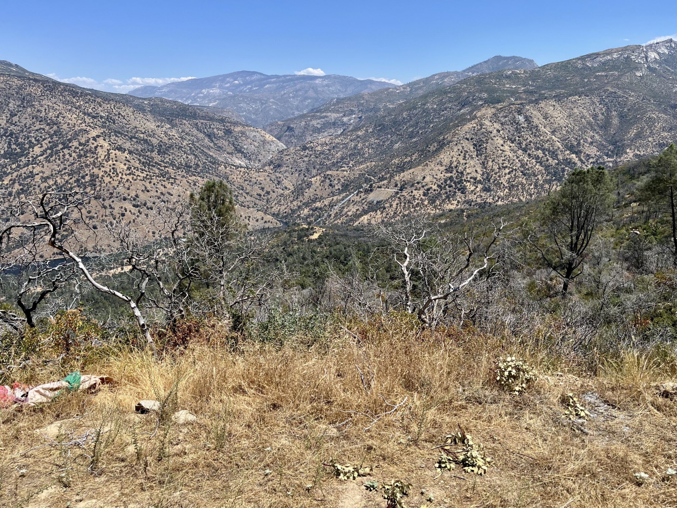
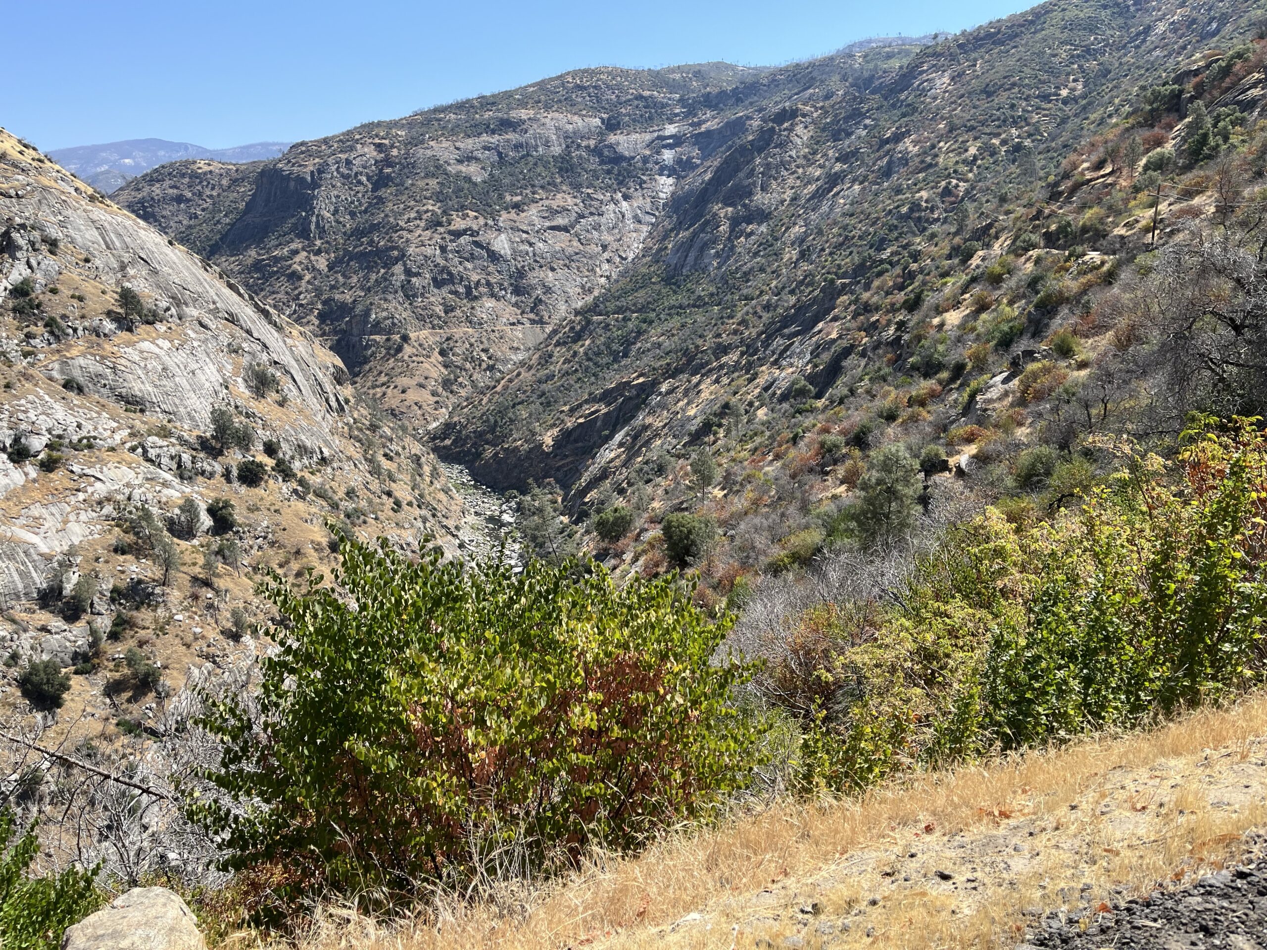
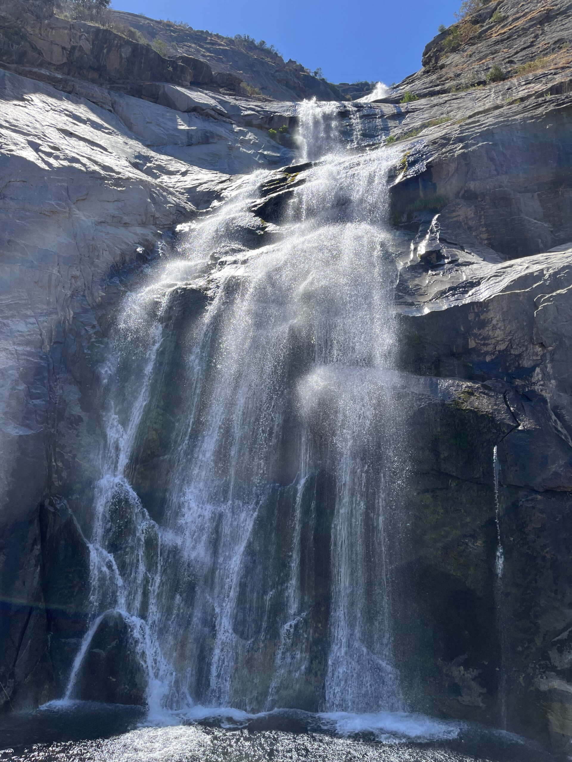
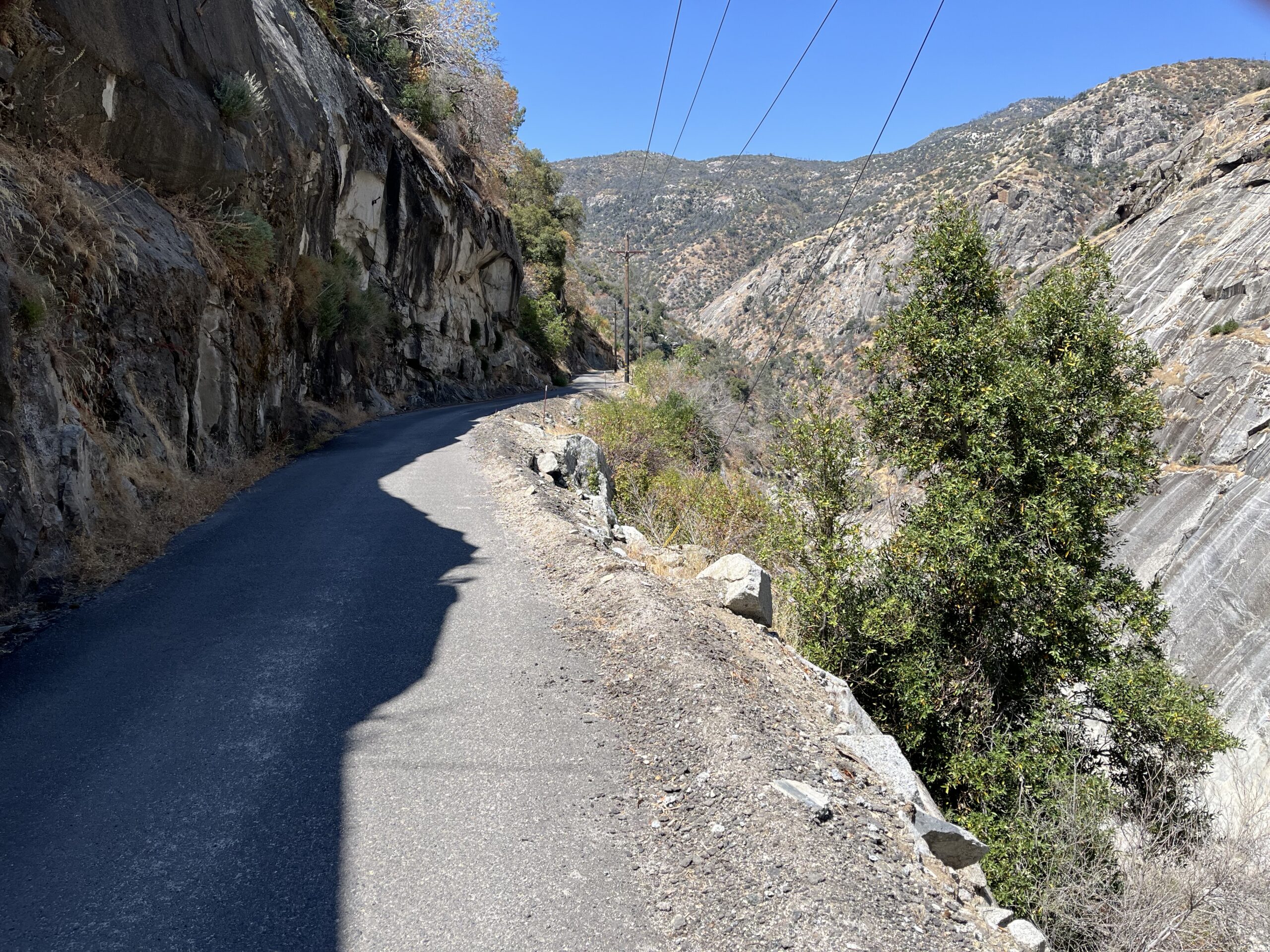
The ride outlined here is the best of the ten, by a long shot, one of the best rides I know of anywhere and a hands-down Best of the Best ride. It’s an 8-mile descent into a rock canyon of indescribable grandeur, then an 18-mile meander between towering granite and marble walls and through a beautiful glacial valley along a perfect Sierra stream. If you ride for the Wow Factor, if you love to be awed, this is the ride for you. There may be other rides as pretty or as pleasant, but none more mighty and imposing. Photos can’t do it justice.
I’ve mapped the ride from the obvious starting place, but if you want to get the climbing out of the way first (and I’m with you), drive to Convict Flat Overlook, park, ride back up the hill to the forest line, turn around and descend to your car, then continue on to Road’s End and turn around.
It’s a big ride—69 miles, 8000 ft of gain. In Shortening the ride I’ll show you ways to cut it down that maintain the grandeur.
By the way, the name of the park and the canyon is Kings Canyon, not King’s Canyon. It’s a translation of Canon de los Reyes, “Canyon of the Magi.”
Distance: 23.6 miles out and back Elevation gain: 1730 ft
This ride isn’t thrilling. But if you’re in the mood for a mellow jaunt through pretty High-Sierra country, you can’t beat it. It’s a idyllic ride, perfect for a recovery day after you’ve tackled one of the harder rides in the area—Carson Pass, Ebbetts Pass, or Monitor Pass—or for a day when you only have an hour or two in the morning or evening to ride. It’s all easy climbing (1730 ft. in 24 miles), with a brilliant blue Sierra lake at the turn-around for snacking or meditation.
Blue Lakes Road isn’t plowed in winter and is therefore impassable above the snow line.
(The RidewithGPS map shows the pavement lasting longer than I think it does.)
Begin at the junction of Blue Lakes Road and Highway 88, which you pass on the Carson Pass Plus ride. There is no “Blue Lakes Road” sign per se, but there are signs reading “Blue Lakes 12” from either direction on 88. There is a nice dirt area for parking on the SE corner of the intersection, and if you don’t like leaving your vehicle on roadsides it’s a pleasant, flat ride from Sorensen’s Resort (which seems to have been renamed Desolation Hotel—see the Carson Pass Plus ride for details).
Just your basic pretty Sierra scenery
Ride to the end of the road. After the first couple of miles of flat, You’ll climb pleasantly for about 6 miles, then climb moderately for a mile to a summit at mile 9, then descend 2 miles to a junction at Lower Blue Lake.
As you ride, enjoy your surroundings. This is not the time or place to hammer or train. You’ll pass meadows, ponds with dark green conifers reflected in their waters, great boulders, and signs of cattle ranching, with a background of lofty mountains flecked with snow (in season).
Near the summit, looking back on the climb (road visible in center)
At the junction there’s a wooden sign reading “Blue Lakes Basin,” a board with some interesting history, and a map showing that four lakes lie in front of you. If you’re on a gravel bike you can ride to any one of them, but the roads are all dirt, so if you’re on a road bike you have one option: ignoring the road into the campground directly ahead of you, take the road on your R, ride along the edge of the campground until that road turns to dirt, then ride the dirt for 1/4 of a mile along the shore of Lower Blue Lake until you see granite boulders jutting out into the water. You should have the place to yourself. Bliss out.
Lower Blue Lake
On the return you’ll do an untaxing 1-mile-or-so climb back up to the summit, then have some thoroughly pleasant moderate descending for the bulk of your ride home. No hairpins, no daredevil 40-mph straights. It’s all rejuvenating, not draining, and you end the ride fresher than when you started.
Adding Miles: This ride lies between two Bestrides.org rides, Carson Pass Plus and Ebbetts Pass. See both those rides’ Adding Miles sections for other possibilities and information on the area. The miles of road between Sorensen’s and Markleeville are almost all trafficky, straight, monotonous, moderate descending—effortless in this direction but not particularly rewarding.
Distance: 67 miles one way Elevation gain: 3015 ft
Here’s the rare opportunity to ride 67 miles in one direction, all of it really good. This ride is a trip through a lovely aspen-strewn Sierra valley, a famous climb up and over the most scenic of California passes, a long stair-stepping descent back to the foothills, a slalom course through vacation home country, and a final mellow leg though a classic old farming valley. It’s more than anyone is going to ride as an out and back, which is OK because I can only recommend it in one direction, east to west. See Shortening the route below for tips on how to arrange a manageable day if you don’t have a shuttle. I did the ride as part of a 4-day loop tour that started in Sacramento and passed by Lake Tahoe.
The first part of this ride, Hope Valley to Carson Pass, is famous as the fifth and last climb of the Death Ride. Park at Pickett’s Junction, where Hwy 89 meets Hwy 88. The parking is much more comfortable a mile east at Sorensen’s Resort (which seems to have been renamed Desolation Hotel—a great place to see aspens, hike, eat, or just hang out), and I’ll leave you to decide how you feel about using their parking lot if you aren’t spending money there. Ride west on 88 through the beautiful Hope Valley (if you can manage to do the ride in the fall when the Aspens are turning colors, so much the better).
Hope Valley
Soon you leave the valley floor and beginning the stunning ascent to Carson Pass. The climb itself is pretty much of a slog—unvaried 6-7% pitch and pretty straight—but visually there is nothing like it. The last 3 miles of the climb are open in front of you, the road is carved out of solid granite, and the view of Red Lake behind and below you gets more and more striking as you ascend. It all looks easy on paper—about 1500 ft of gain—but the elevation is a famous sapper of legs here, so trying to power up the climb is asking for trouble. I settle in at a docile 5.5 mph, look around at my surroundings, and spin it out.
The climb to Carson Pass
There’s a small Visitor Center at Carson Pass (with bathrooms). It caters to hikers on the Pacific Crest Trail, which crosses the road there, and it’s a friendly and cheerful spot worth a stop. They even have loaner hiking poles. A lovely 2-mile round-trip hike to Frog Lake starts there, if you have an hour and brought hiking shoes.
Caples Lake
If you’re just out for the afternoon, turning around at the Carson Pass summit will give you a 20-mile outing, and you get to see the scenery twice, but I confess the descent from Carson Pass is for me without reward. If you like straight, very fast, wind-blown, brake-straining coasting, you’ll love it.
If you continue on, the scenery stays classic High-Sierra wonderfulness for the next 30 miles—mighty granite, deep green forest, endless vistas. After the fast, sweeping descent from Carson Pass, you meet Woods Lake Road going off to the L, and you can take that road for a short, lovely ride to minute, picture-perfect Woods Lake, an ideal spot for a break, a bit of meditation, or an easy short hike.
Carson Spur
Back on 88, you pass Caples Lake, then Kirkwood Ski Resort, then a moderate climb up to and around Carson Spur, a granite monolith (stunning vistas off to your right). Then it’s down to Silver Lake, a lovely area to take a break (more secluded than Caples) or camp. Past Silver Lake you do a straight, tedious climb (a tough way to start the day if you camped at the lake), descend, and begin watching for Mormon Emigrant Trail on the R. It’s prominent, but the main road is a fast descent here and you can blow past it.
View from Mormon Emigrant Trail
Mormon Emigrant Trail, despite its name, is a road—a big, wide, fast roller coaster. It’s like Hwy 88 cubed—smaller, windier, same great vistas, and lots less traffic. It rolls up and down, mostly down, and it loses a lot of elevation over its length, so it’s tons of fun going east to west, with just enough climb in the rollers to make you feel like you’re earning this. Going west to east, the elevation change works against you, and that’s the only real obstacle to doing this ride in the other direction. Just past halfway you’ll pass the turn-off to North South Road, in our list.
Mormon Emigrant Trail debouches at Jenkinson Lake, AKA Sly Park, and the ride changes. Cross the dam and stay L onto Sly Park Rd., which traverses pretty wooded country but is built up with vacation homes and thus can be heavily trafficked. It’s a rollicking slalom descent, so if you can catch a break in the traffic it’s an absolute hoot—with traffic, the cars keep making you slow down. Stay on Sly Park all the way to Diamond Springs.
Mormon Emigrant Trail
If the traffic is bothering you, there’s an escape route: Sierra Springs Drive (or Road). It takes off to the R soon after you start down Sly Park Rd. from the lake. Most maps think it’s a dead-end residential road into a subdivision, and it was, but if you summon your blind faith in me and head down it, it goes through the subdivision through a few spectacular esses (worth the detour by themselves) and turns into Starkes Grade Rd., which is a road so small it might as well be a rec path, and which descends gently along the most gorgeous little creek you’ve ever seen. You’ll think you’re in a Japanese garden. It’s a very special place. Our mapped route goes that way. Starkes Grade ends on Newton Rd., and you’ll need to go L on Newton for a ¼ mile or so to get back on Sly Park.
Somewhere in here Sly Park Rd. changes its name to Pleasant Valley Rd., and that tells you exactly what you’re in for: a very pleasant, easy ride through a traditional farming valley. Ride to Diamond Springs, where the riding quality drops off precipitously and our ride stops.
Shortening the route: If you only have one day and you can’t arrange a shuttle, I suggest you start at Carson Pass, look at the vista to the east, then ride west as far as you wish, then return. It’s 17.5 miles to the Mormon Emigrant Trail turn-off, and those miles will give you 3 lakes, 1 rock monolith, and lots of grand vistas. If you want a little less, turn around at Silver Lake. Remember, it’s uphill almost all the way back.
Adding miles: There’s good riding all around you on this ride. Near the beginning of this route you pass the turn-off for the Blue Lakes Road ride, and from the starting point you can ride east and south (mostly long, steady, trafficky descents) to Markleeville, a charming town with restaurants and a general store, and smack onto the Ebbetts Pass ride.
From the Diamond Springs end you’re close to an endless supply of good roads. Just north of you is Placerville, home to several good restaurants and the best hardware store in the world. Our Mosquito Rd. loop takes off from Placerville. See the Adding Miles section of that ride for other routes north of town. Going south from Diamond Springs, backtrack up Pleasant Valley Rd. to Bucks Bar Rd. on your R, take it to Somerset, and Mt. Aukum Rd. going south out of Somerset leads to the entire lower Gold Country. At this point, the world is your oyster.
Afterthoughts: The Hope Valley Cafe/Resort, 1/4 of a mile east of Sorensen’s, one of those character places beloved by those in the know, seems to be permanently closed.
There are opportunities to resupply at the resorts at Silver Lake and Caples Lake (Silver has a resort at each end), and at the Kirkwood Inn (right on the highway, though the Kirkwood ski area itself is not). There’s water (for sale, I think) at the Carson Pass Visitor Center. There are no services on Mormon Emingrant Trail.
Carson Pass is kept free of snow in the winter, except for the occasional temporary avalanche. Mormon Emigrant Trail is not.
The Death Ride has made its three summits—Carson, Monitor, and Ebbetts—famous. The three climbs are very different. Carson Pass—included in the Carson Pass Plus ride—is an almost straight slog whose selling point is its magnificent vistas. Monitor Pass is a monotonous, seemingly endless grind up through featureless high desert country I find esthetically without merit, though in truth you can see a long way from it. Many riders love it. I think it comes down to how you feel about 50-mph descents. I don’t care for them, so Monitor isn’t in my list.
Ebbetts Pass, on the other hand, is one of the four or five best rides in California, a challenging but always rewarding climb along rocky steams and through pretty Sierra Nevada forest surrounded by classic High Sierra granite and big canyon views, with a road contour that is constantly varying—no long, tedious slogs, I promise. And the descent is even better—very much in the running for best descent in California. The road surface is as good as a road surface that experiences California high-country winters can be—the top few miles are a bit rough on the descent but most of it is close to glass.
Highway 4 is a “major” route through the Sierras, but it has little traffic, because most cars choose other routes. Unless you’re doing this ride on a summer weekend (never a good idea), once you leave Carson River, which is busy with fishermen in the summer, you should be pretty much alone. I last rode it on a weekday morning in September, and I saw 15 vehicles, or slightly more than a car every two miles. And the sight lines are grand, so the few on-coming cars announce themselves in advance.
The Carson River canyon before sunrise
Ebbetts Pass is closed by snow in the winter. It’s usually plowed sometime in late June. Check highway reports before heading out there.
You shouldn’t need to resupply water on this ride, but if you do, there are two formal campgrounds along Hwy 4. On hot days I take a third water bottle and cache it when the climbing gets taxing.
(Note 2022: Yosemite, Mariposa, and the surrounding region have been hit hard by forest fires in the last 2 years. The Mariposa area was on fire in the summer of 2022. I don’t know how severely the riding has been impacted, but the effect of the fires must have been significant.)
I was introduced to this four-day tour by the Sacramento Bike Hikers, who used to do it every year. The loop has enormous scenic variety and an iconic destination that amps up the drama from the first pedal stroke. Not every mile is rewarding. There’s some boring flat straight stuff in the beginning, there’s some traffic dodging on the Yosemite roads, there are two stretches of rough road surface, and there are way too many people in the Park. Yet it remains a grand, bucket-list experience. Just say it with me: “riding my bike to Yosemite.” You’re down for it, I know.
It’s not at all daunting. The climbing is mostly quite mellow, and there’s only one longish day, and that’s almost all downhill. For that and other reasons, I don’t recommend trying to shorten the ride. This is one of those rides you want to keep epic. Try to talk a friend into driving a sag wagon. But I’m a realist, so after we walk through the tour we’ll talk about ways to shorten it.
If you have a National Park pass of some sort, remember to pack it and your ID before setting forth. It does no good to remember it on Day 3 as you approach the Park entrance.
Day 1: Merced to Mariposa
Distance: 49 miles one way Elevation gain: 2630 ft